


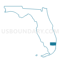
J007-Voting District, Broward County, Florida
About
Outline

Summary
| Unique Area Identifier | 552087 |
| Name | J007-Voting District |
| County | Broward County |
| State | Florida |
| Area (square miles) | 0.09 |
| Land Area (square miles) | 0.09 |
| Water Area (square miles) | 0.00 |
| % of Land Area | 100.00 |
| % of Water Area | 0.00 |
| Latitude of the Internal Point | 26.20686220 |
| Longtitude of the Internal Point | -80.27455570 |
Maps


Graphs
Select a template below for downloading or customizing gragh for J007-Voting District, Broward County, Florida


Neighbors
Neighoring Voting District (by Name) Neighboring Voting District on the Map
Top 10 Neighboring County Subdivision (by Population) Neighboring County Subdivision on the Map
- Plantation CCD, Broward County, FL (261,673)
- Coral Springs-Margate CCD, Broward County, FL (217,025)